

Mud in the streets of Funchal: the Madeira floods of 20 February 2010
After the wettest winter on record, a morning of rain turned the short, steep streams of Madeira's south coast into torrents of mud and rock. The disaster left about fifty people dead or missing and a long argument about what had been built in the ravines.
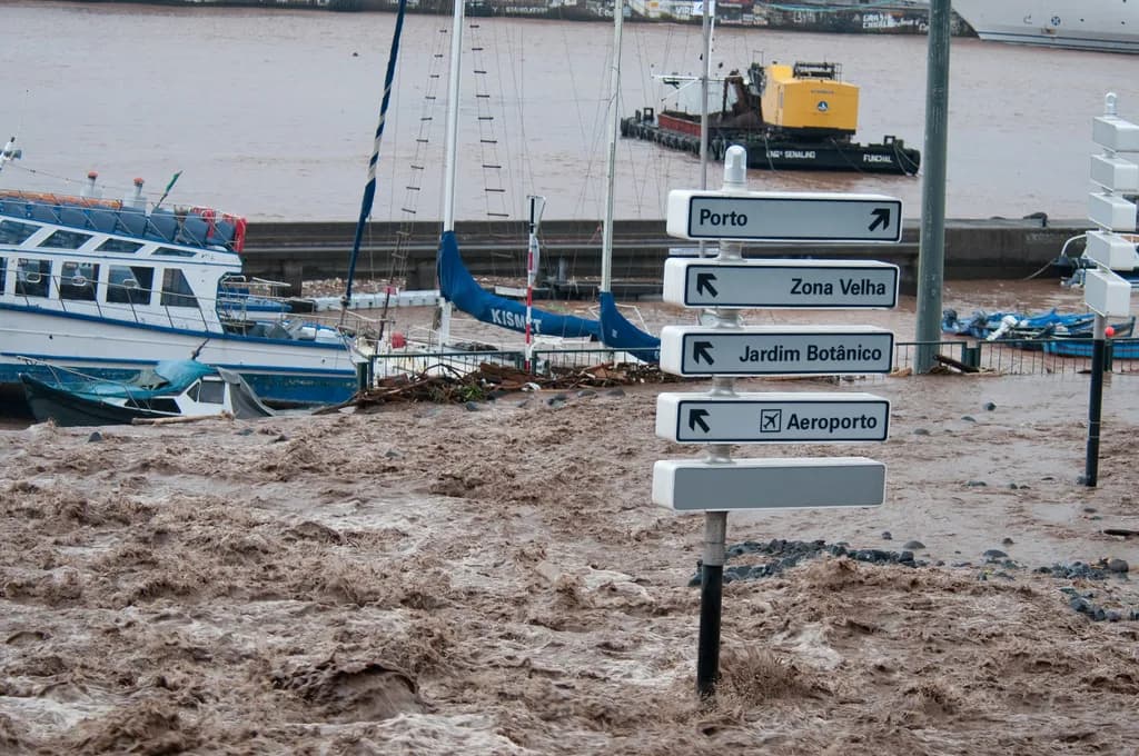
At a glance
- On Saturday 20 February 2010 about 14 hours of rain fell on Madeira. The weather station in Funchal recorded 111.5 mm in six hours and 144.3 mm in the day, more than twice the normal total for February.
- The rain set off thousands of landslides in the mountains. Mud, boulders and tree trunks poured down the short streams, called ribeiras, into Funchal and the Ribeira Brava valley.
- Counts of the dead differ: scientific studies give 45 dead and 6 missing, a 2011 press report 48 and 7, and Lusa and the Diário de Notícias now 47 and 4. About 250 people were injured and about 600 lost their homes.
- Damage was put at €1,080 million. A special law of June 2010, the Lei de Meios, gave Madeira €740 million from Lisbon, and the EU Solidarity Fund added €31.3 million.
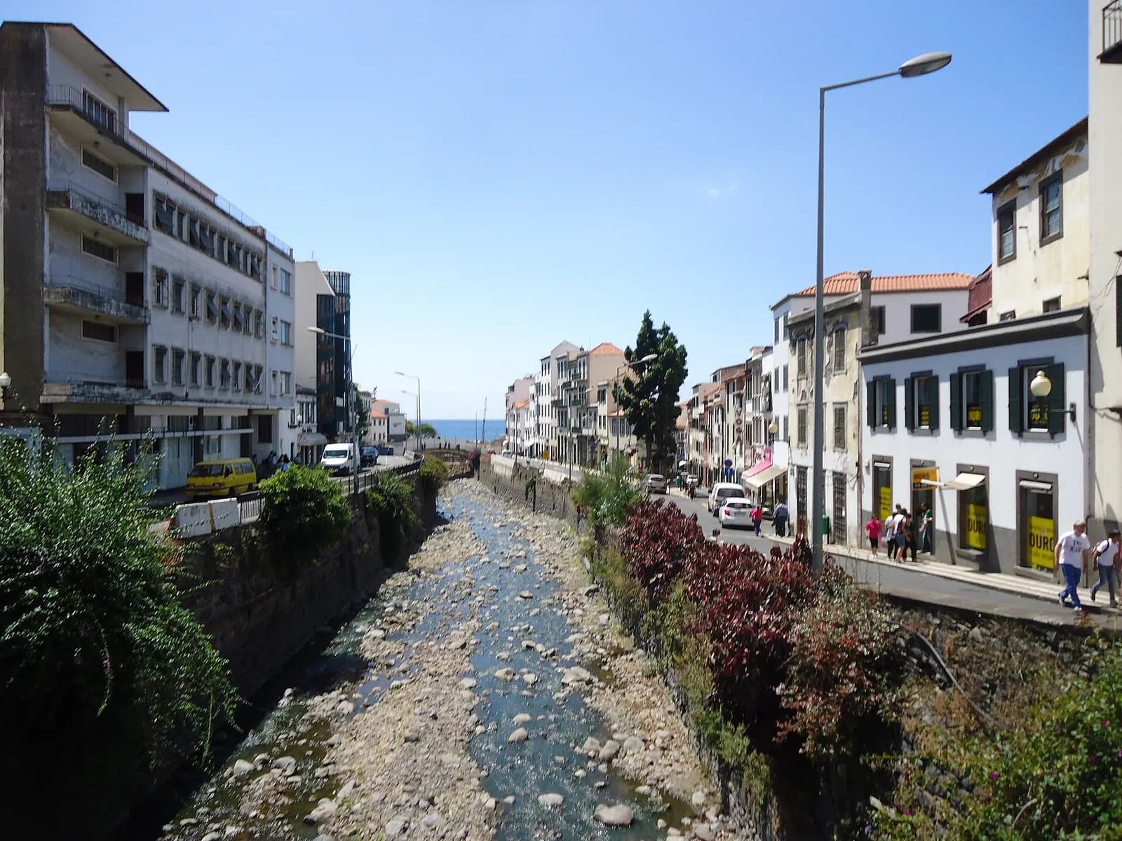
- Funchal's ribeiras have since been rebuilt and twelve barriers built upstream to catch boulders, but in 2020 a geological engineer warned that some channels through the city were still too narrow.
A Saturday morning in Funchal
It had been raining since before dawn. Between 8.50 and 9.50 on the morning of Saturday 20 February 2010, the weather station at the Funchal observatory caught 51.3 millimetres of rain, a rate expected there perhaps once a century. Up in the mountains above the city, the gauge at Areeiro took 78.5 millimetres in the same hour, and by 11 o'clock 111.5 millimetres had fallen on the observatory in six hours.
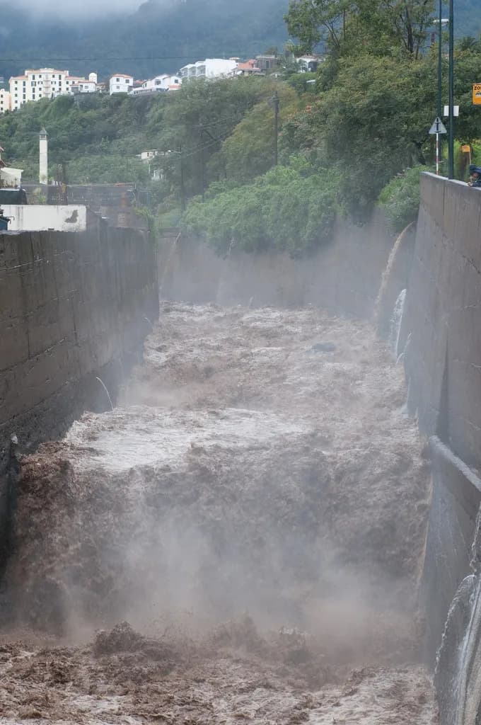
The three streams that run through the centre of Funchal, the Ribeira de São João, the Ribeira de Santa Luzia and the Ribeira de João Gomes, filled with a brown slurry of water, mud and rock. The João Gomes tore a pump out of a petrol station and carried a large fuel tank through the lower town. The São João burst out of its channel beside the Dolce Vita shopping centre, and the marina at its mouth filled with wreckage.
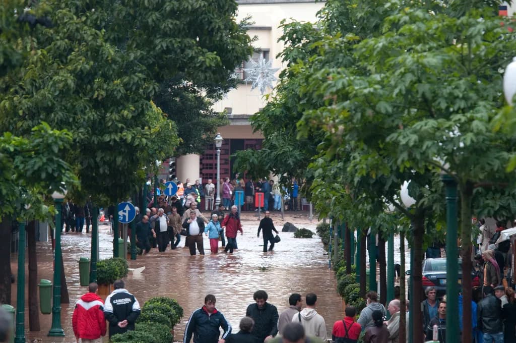
In Rua Pedro José de Ornelas, known as Rua da Pena, water pouring down from the Estrada Luso-Brasileira turned the street into a stream, and several people were swept away and killed, among them a child. Police evacuated buildings in Rua Dr. Fernão de Ornelas in the city centre. On the other side of Funchal, in the high valley of Curral das Freiras, the only road out was damaged and the village was cut off.
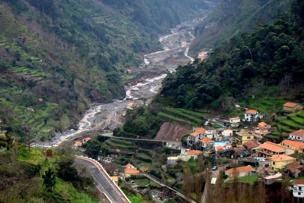
West of Funchal, the Ribeira Brava valley took the second core of the storm. In the parish of Serra de Água, houses and cars were swept away, and the town of Ribeira Brava at the mouth of the valley was flooded. When Funchal's Diário de Notícias went to press that night, it counted 32 dead, 101 injured and 250 people driven from their homes.
An island of ravines and aluviões
Madeira is a volcanic island of 740.7 square kilometres in the subtropical Atlantic, and with Porto Santo it forms an autonomous region of Portugal. Its mountains rise to 1,861 metres at Pico Ruivo and run east to west, so the moist north-easterly winds hit them almost head on. At the 2011 census the region had about 267,000 people, most of them on Madeira's south coast in and around Funchal, one of Europe's earliest tourist destinations.
The streams of the south coast are short and steep. The five basins that did the damage in 2010 cover between 8.8 and 15.6 square kilometres each, except the Ribeira Brava at 40.9, with average slopes of 25 to 37 degrees. The risk study estimated that rain falling on their headwaters reaches the sea in little more than an hour. In summer their beds are dry and full of loose boulders waiting for the next flood to move them.
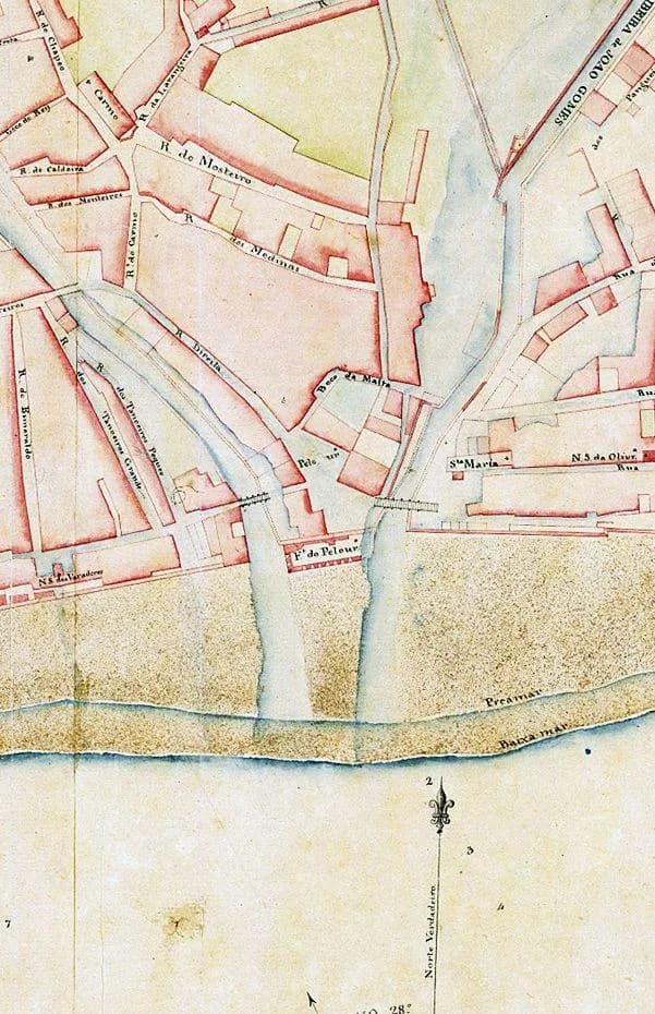
The island's history is full of them. The worst on record came on 9 October 1803, when between 800 and 1,000 people died, most of them in Funchal. After it the military engineer Reinaldo Oudinot channelled the city's streams between stone walls, work carried out from 1804 to 1806. Aluviões kept coming in the two centuries that followed, but none was as severe as the one of 2010.
| Date | Worst-hit area | Dead and damage |
|---|---|---|
| 9 October 1803 | Funchal | 800 to 1,000 dead |
| 6 March 1929 | São Vicente | 32 dead, 11 houses and 100 straw huts destroyed |
| 23 and 24 January 1979 | Machico, Porto da Cruz, Camacha, Canhas, Calheta and Fajã do Penedo | 14 dead |
| 29 October 1993 | The whole island | 4 dead, 4 missing, 27 injured, 306 displaced |
| 5 and 6 March 2001 | Curral das Freiras and São Vicente | 5 dead (German tourists), 120 displaced |
| 20 February 2010 | Funchal and Ribeira Brava | 45 to 48 dead, 4 to 7 missing |
From the regional government's 2010 risk study (EARAM), which lists smaller floods too. Fragoso and colleagues, drawing on the same study, give 40 dead for 1929 and 4 for 2001. The 2010 range is explained in the section on the dead below.
The wettest winter on record
The storm fell on ground that was already soaked. From 1 October 2009 to the end of February 2010 the Funchal observatory recorded 1,016.6 millimetres of rain, against an average of 426.4 for those five months. The rain of January and February alone came to about 90 per cent of a normal year.
Monthly rainfall at the Funchal observatory, October 2009 to February 2010
mm
- 1971-2000 average
- 2009-10
February 2010 brought 458.7 mm to Funchal, about seven times the 1971-2000 average of 64.5 mm. Figures from the Instituto de Meteorologia's February 2010 bulletin for Madeira.
Show the data
| 1971-2000 average | 2009-10 | |
|---|---|---|
| Oct | 80.9 | 96.5 |
| Nov | 84.4 | 66.2 |
| Dec | 106.2 | 286.1 |
| Jan | 90.4 | 109.1 |
| Feb | 64.5 | 458.7 |
February was the extreme. Its 458.7 millimetres made it the wettest February in Funchal since records began in 1865. In the mountains the numbers were larger still: the Areeiro gauge, at 1,590 metres, collected more than 4,000 millimetres between October and February, the wettest such season there since 1937.
There had been warnings. On 22 December 2009 an aluvião destroyed roads and houses at Madalena do Mar and São Vicente. On 2 February 2010 Funchal took 129.8 millimetres in a day, its wettest February day since daily records there began in 1949, and a stream at Faial on the north coast flooded. Scientists later wrote that the winter's rain had saturated the soil and loaded the slopes with loose material before the storm of the 20th arrived.
The cause lay far to the north. That winter the North Atlantic Oscillation, the seesaw of air pressure between Iceland and the Azores, was in a record negative phase. That pushes the track of Atlantic storms south, and it brought low after low across Madeira and southern Iberia.
Fourteen hours of rain
At midnight on the 20th a deep depression sat near the Azores, with its fronts trailing south into the subtropics. As they moved east, a plume of warm, wet air, probably of tropical origin, was driven onto Madeira by south-westerly winds of up to 30 metres a second at mountain height. The island lay under the point where the fronts met, and great towers of cloud built over it.
The weather balloon launched from Funchal at midday showed how much water the air held. The precipitable water, the depth of rain the column of air would give if all its vapour fell, had risen from 13.4 millimetres the day before to 37.0, and it stayed that high even after hours of downpour. Madeira had no weather radar in 2010, so forecasters could not watch the storm cells as they crossed the island.
03:00 to 05:00
Rain begins over most of the island
From 08:00
The rain grows heavier on the southern slopes, first on the lower and middle slopes around Funchal
08:50 to 09:50
Funchal's wettest hour: 51.3 mm at the observatory, 78.5 mm at Areeiro
09:00 to 10:00
The Trapiche gauge above Funchal takes 88.4 mm in an hour, more than twice the 42.2 mm at a gauge 3 km away
09:45 to 11:45
The longest-lived storm cell sits almost still over the island
About 11:00
The rain peaks in the mountains as landslides and floods are already under way
13:00 to 14:00
The rain eases, but heavy falls continue in the headwaters until about 14:00
About 17:00
The rain stops
Rain gauges a few kilometres apart told different stories. Over half the island had more than 250 millimetres that day, with two cores of 250 to 370 millimetres: one over the high plateau of Areeiro, at the head of Funchal's streams, and the other over Paúl da Serra and Encumeada, at the head of the Ribeira Brava. Funchal sat inside a crescent of the heaviest rain.
| Station | Wettest hour (mm) | Wettest 6 hours (mm) | Day total, 00:00 to 24:00 (mm) |
|---|---|---|---|
| Areeiro (mountains above Funchal) | 78.5 | 272.1 | 387.1 (gauge failed from 18:00) |
| Funchal observatory | 51.3 | 111.5 | 144.3 |
| Lugar de Baixo, Ponta do Sol | 38.7 | 89.8 | 95.3 (gauge failed from 12:00) |
| Calheta, Ponta do Pargo | 41.7 | 85.5 | 97.4 |
| Caniçal, Ponta de São Lourenço | 21.3 | 40.5 | 42.2 (gauge failed from 12:00) |
| Porto Santo airport | 7.5 | 17.0 | 20.9 |
| Santana, Ponta de São Jorge | 8.8 | 17.9 | 20.0 |
Instituto de Meteorologia, February 2010 bulletin. Other networks give slightly different totals: Fragoso and colleagues use 146.9 mm for Funchal and 333.8 mm for the Areeiro gauge of the regional engineering laboratory, and Lira and colleagues give 108 mm for Funchal between 6 and 11 am.
Statistically it was an extreme day, especially low down. Fragoso and colleagues put the return period of Funchal's daily total at about 290 years and that of Areeiro at about 90, while warning that such long return periods rest on only some 70 years of records. The risk study, working from the observatory's shorter hourly records, put Funchal's six- to twelve-hour totals at about a 1,000-year event.
By Fragoso's count, about 80 per cent of Funchal's rain fell in six hours, and the 114.8 millimetres of that spell beat the highest six-hour total of 1980 to 2009, 92.6 millimetres on 27 September 1989.
Mud and boulders
Rain alone would have flooded the streets. What made the day so deadly was the rock. A survey from satellite images and fieldwork found 3,291 landslides in the Funchal basins and about 5,170 in the Ribeira Brava area, most of them high up in the basins. Together they fed soil, stones and trees into stream beds that already held loose material, which the flood also picked up.
The streams carried blocks of 10 to 15 tonnes from above 800 metres down to the city centre; the water in these floods can reach 60 to 80 kilometres an hour, according to researchers from the University of Aveiro. A model of the Ribeira de São João by the risk study team showed a steep front of debris moving downstream at an average of 2.6 metres a second, dropping its load wherever a narrowing of the channel slowed it down.
- Peak flow, Ribeira Brava
- About 663 cubic metres a second
- Peak flow, São João and Santa Luzia
- About 305 and 303 cubic metres a second
- Peak flow, João Gomes
- About 234 cubic metres a second
- Landslides counted
- 3,291 above Funchal, about 5,170 around Ribeira Brava
- Sediment left in Funchal
- At least 250,000 cubic metres, and up to 390,000 by the regional government's figure
When the water drained away, central Funchal was buried. Clearing the streets and the lower stream channels produced about 140,000 cubic metres of fill, which was dumped by the city's wharf, and about 100,000 more were dredged from the port. The finest mud washed out to sea. The risk study and Lira and colleagues estimate that at least 250,000 cubic metres of sediment came to rest in Funchal alone; the regional government later put the material left in the city's channels and streets at up to 390,000.
The Ribeira Brava was hit just as hard. It had the biggest peak flow of the five basins studied, and the volume of slope material that slid into its streams was put at between 605,000 and 984,000 cubic metres, against 217,000 to 344,000 for the three Funchal basins.
Counting the dead
The count rose for days. By Monday 22 February it stood at 42. Telephone lines had been cut, and Francisco Ramos, the regional secretary for social affairs, said that 85 people reported missing had turned up at home; they had simply been unable to reach their families. The government in Lisbon sent three diving teams, 43 doctors, a group of firefighters and a navy frigate.
There is still no single final figure. Two scientific studies, published in 2012 and 2013, give 45 dead, 22 of them in Funchal, and 6 missing. Correio da Manhã, reporting the close of the criminal inquiry in April 2011, gave 48 dead and 7 missing. On the tenth anniversary the Lusa news agency gave 47 dead and 4 missing, the figures the Diário de Notícias also uses. The usual figures for the injured and the homeless are about 250 and about 600.
| When | Source | Dead | Missing | Other |
|---|---|---|---|---|
| Night of 20 February 2010 | Diário de Notícias, first edition | 32 | 101 injured, 250 displaced | |
| 22 February 2010 | Wire reports from Lisbon | 42 | 85 people reported missing found alive | |
| 28 March 2010 | Silva, Almeida and Gomes, Diário de Notícias | 43 (29 in Funchal) | 8 | About 600 displaced |
| 2012 and 2013 | Scientific studies by Fragoso and by Lira and colleagues | 45 (22 in Funchal) | 6 | 250 injured, 600 homeless |
| April 2011 | Correio da Manhã, close of inquiry | 48 | 7 | |
| February 2020 | Lusa news agency; also Diário de Notícias, 2024 | 47 | 4 |
None of these sources explains how its figure was reached, and no source found for this article reconciles them.
Fragoso and colleagues called it the deadliest weather disaster in Portuguese territory in four decades. The flash floods around Lisbon in November 1967 had killed 462 people by the official count, and more than 500 by later scientific estimates. The Public Prosecutor's Office closed its inquiry into the deaths in April 2011. Francisco Ramos called the decision the end of a painful process for the families.
Paying for the damage
The government in Lisbon treated the disaster as a national emergency. On 15 March 2010 it set up a joint commission with the regional government to count the cost, and in April the commission put the damage at €1,080 million, or about 0.68 per cent of Portugal's gross national income. The international disaster database EM-DAT gives US$1.9 billion.
Estimated damage by type, February 2010 floods
€ million
The joint commission's estimate of April 2010, total €1,080 million, as published by the Madeira section of the Tribunal de Contas (Court of Auditors) in 2011.
Show the data
| Estimated damage | |
|---|---|
| Rivers and streams | 488 |
| Roads | 236 |
| Ports and coast | 127 |
| Economic activity | 122 |
| Water, power and sewers | 71 |
| Housing | 36 |
The largest share, 45 per cent, was for the streams themselves: about 130 kilometres of watercourses had to be cleared and repaired, 26 main streams and 250 smaller ones. Some 153 bridges were damaged, 66 of them in Funchal. About 3,100 farms suffered losses, and around 800 houses were damaged, 400 of them destroyed, partly destroyed or left structurally unsound.
A special funding law followed, Organic Law 2/2010 of 16 June, known as the Lei de Meios. It gave Madeira €740 million over four years to the end of 2013: €200 million from the state budget, €265 million from the EU Cohesion Fund, a €250 million loan from the European Investment Bank and €25 million from the central investment programme. The remaining €340 million was to come from the regional and municipal budgets, EU regional programmes and private money.
Portugal also applied to the EU Solidarity Fund on 20 April 2010, and on 5 April 2011 it was awarded €31.255 million. The money came slowly at first: by the end of 2010 the region had received €191.3 million under the Lei de Meios and paid out €56.3 million.
Ten years on, the regional government said it had spent €631 million: €556.3 million on reconstruction and protection works, €43.1 million on businesses and farms and €31.6 million on housing. About 1,200 households whose homes were hit had received help, and the regional housing company had rehoused 198 families and steered 220 more towards repairing their own homes. Six households were still waiting for a permanent solution.
Building in the ravines
Five weeks after the floods, three researchers from the University of Aveiro, the geological engineer João Baptista Pereira Silva, the mining engineer Fernando Ernesto Almeida and the geologist Celso Gomes, set out their case in Funchal's Diário de Notícias. Of the 22 aluviões of the twentieth century, they noted, 13 had come since 1970. They suggested three possible reasons: a changing climate, more ground sealed under concrete and asphalt, and the occupation and narrowing of the stream beds.
Their list of what stood on the banks and flood plains of Funchal's streams was long: businesses, sports grounds, health centres, fire stations, electricity substations, bus depots, waste plants, family homes and blocks of social housing.
Until the 1940s, they wrote, the lower Ribeira de São João ran in the open to the beach at São Lázaro. It was then closed in and narrowed step by step: by the Infante roundabout, the marina wall, new apartment and office blocks and, most recently, the foundations of the Funchal Centrum, the building of the Dolce Vita shopping centre. On 20 February the stream overflowed on the stretch between that building and the marina.
They also blamed the deep basements dug under the old town for car parks and stores, in some cases 30 metres deep. These flooded on the 20th, and at the Anadia shopping centre 50 million litres of water had to be pumped out of the car park. In 2006 the same team had published a study of these underground works, and they wrote that about 90 per cent of the risk situations it had identified came about in the floods.
The regional government asked the Instituto Superior Técnico in Lisbon, the University of Madeira and the regional engineering laboratory for a risk study, known by its Portuguese initials as EARAM. Carried out from May to December 2010, it proposed works to hold back solid material in the headwaters, to catch boulders in barriers above the towns, to clear obstructions from the channels through them and to control what could be built near the streams. Homes on slopes where the risk was intolerable, it said, should be removed.
“It is, however, important to recognise that the scarcity of space with conditions suitable for settling the population in Madeira creates considerable pressure to accept a higher level of risk and to occupy exposed areas.”
What was built afterwards leaned heavily on engineering. A 2015 review for the regional climate strategy listed several dozen protection works finished, under way or planned since February 2010; 40 of them were works on stream channels, against 11 to stabilise slopes and 3 to hold back sediment. Four boulder barriers went up on each of Funchal's three main streams, twelve in all, which the regional government says can hold back about 64 per cent of the material that reached the city in 2010. A weather radar now stands on Porto Santo.
Planning moved more slowly. The first flood risk management plan, drawn up in 2016, listed 27 critical zones in ten municipalities of Madeira and in Porto Santo. Oliveira wrote in 2020 that its rules still had to be made to work in the licensing of new buildings. Reforestation of the mountains is part of the strategy too, though he notes that large trees can do damage and block channels when a flood carries them off.
The argument has not ended. In October 2020 the geological engineer João Baptista warned that the Ribeira de Santa Luzia and the Ribeira Grande de Santo António were still too narrow, and that what happened at Serra de Água in 2010 could happen in the capital. The regional infrastructure department replied that it respected the researchers but stood by a strategy followed since 2010.
Why it still matters
In Madeira the disaster is often called simply the 20 de Fevereiro. The barriers above Funchal, the rebuilt channels and the weather radar on Porto Santo all came out of it, and so did a long effort to spread a civil protection culture across the population.
The scientists who studied the storm stress that the conditions behind it are part of the island itself: short, steep valleys, loose rock and rain that can come in bursts of 100 millimetres an hour. Engineering can catch boulders and widen channels, but where homes stand in the flood path, the risk remains. The risk study said as much in 2010, and Oliveira said it again ten years later.
FAQs
How many people died in the Madeira floods of 2010?
Figures differ. Scientific studies published in 2012 and 2013 give 45 dead and 6 missing; a press report on the close of the criminal inquiry in 2011 gave 48 dead and 7 missing; and the Lusa news agency and the Diário de Notícias have given 47 dead and 4 missing since 2020. About 250 people were injured and about 600 were left homeless.
How much rain fell on 20 February 2010?
The Funchal observatory recorded 144.3 mm between midnight and midnight, 111.5 mm of it in six hours and 51.3 mm in the wettest hour. In the mountains the Areeiro station recorded at least 387.1 mm before its gauge failed. Over half the island had more than 250 mm.
What is an aluvião?
It is the Madeiran word for a flash flood that carries large amounts of mud, rock and debris down the island's short, steep streams. Geologists call it a debris flow. It is the most dangerous natural hazard on Madeira; the worst on record, in October 1803, killed between 800 and 1,000 people.
What has been done to protect Funchal since 2010?
The streams through Funchal were cleared and rebuilt, twelve barriers were built upstream on the three main streams to catch boulders, a weather radar was installed on Porto Santo and a first flood risk management plan was drawn up in 2016. Critics say some channels are still too narrow and that too much is built in the flood path.
On the timeline
Open the timelineNearby moments from portugal in europe (1986–today).
Cristiano Ronaldo is named FIFA World Player of the Year in Zurich after winning the Premier League and the Champions League with Manchester United — the first Portuguese winner since Luís Figo in 2001.
Sculptor Lagoa Henriques dies in Lisbon. His best-known work is the bronze Fernando Pessoa seated at a café table outside A Brasileira in the Chiado, unveiled in 1988 for the poet's centenary — the empty chair beside him has made it a favourite photo stop for visitors.
Raul Solnado, one of Portugal's most beloved comedians and actors and a defining figure of Lisbon's Parque Mayer theatre scene, dies in Lisbon aged 79.
The Madeira floods of 2010
Torrential rain unleashes flash floods and mudslides on Madeira, sending torrents of water, boulders and mud through Funchal and other towns. Funchal recorded 108 mm of rain in five hours, more than a normal February's total; 51 people were killed or left missing and around 600 lost their homes.
Pope Benedict XVI arrives in Lisbon for a four-day visit to Portugal, celebrating an open-air Mass on the Terreiro do Paço before travelling on to Fátima for the anniversary of the apparitions and ending his trip in Porto.
President Aníbal Cavaco Silva signs the law opening civil marriage to same-sex couples, making Portugal the sixth country in Europe and the eighth in the world to do so. On 7 June, Teresa Pires and Helena Paixão, whose 2006 court challenge began the fight, become the first same-sex couple to marry in Portugal, at a Lisbon registry office.
Death of José Saramago in Tías, Lanzarote, at the age of 87. The novelist, winner of the 1998 Nobel Prize in Literature — the only Portuguese-language writer ever to receive the award — was author of 'Memorial do Convento', 'O Evangelho Segundo Jesus Cristo' and 'Ensaio sobre a Cegueira'. His ashes are later buried beneath an olive tree outside the Casa dos Bicos, his Lisbon foundation.
Coming up in history
All long reads 22 February 1943The Yankee Clipper crash: when a wartime flying boat fell into the Tagus
 23 February 1987Zeca Afonso, the singer of ‘Grândola’, dies in Setúbal: 23 February 1987
 24 February 1843Teófilo Braga, the Azorean scholar who led the Republic’s first government
 25 February 1869The 1869 decree that abolished slavery in the Portuguese empire, on paper
17 sources
Archives, scholarship and reporting this article was checked against.
- 1
The 20 February 2010 Madeira flash-floods: synoptic analysis and extreme rainfall assessmentM. Fragoso, R. M. Trigo, J. G. Pinto, S. Lopes, A. Lopes, S. Ulbrich and C. Magro, Natural Hazards and Earth System Sciences, vol. 12, 2012, pp. 715-730
- 2
Boletim Climatológico Mensal da Madeira, Fevereiro 2010Instituto de Meteorologia (now IPMA), Observatório Meteorológico do Funchal, March 2010
- 3
A avaliação do risco de aluviões na ilha da MadeiraRodrigo Proença de Oliveira, António Betâmio de Almeida and colleagues, Instituto Superior Técnico and LREC (summary of the EARAM study, 2010), via Portugal 2020
- 4
- 5
Acompanhamento das medidas de apoio à reconstrução da RAM na sequência da aluvião de 20/02/2010, Ano de 2010 (Relatório n.º 6/2011-FC/SRMTC)Tribunal de Contas, Secção Regional da Madeira, 2011
- 6
Aprender com a natureza: enxurradas e inundações na Madeira (João Baptista Pereira Silva, Fernando Ernesto Almeida and Celso de Sousa Figueiredo Gomes)Diário de Notícias (Funchal), 28 March 2010, copy held by the Museu Geológico, Instituto Superior Técnico
- 7
Contributos para uma estratégia integrada de gestão do risco de aluviões na ilha da MadeiraRodrigo Proença de Oliveira, in Madeira Região Resiliente: Aprender com o Passado (Estudos Cindínicos), RISCOS, Coimbra, 2020
- 8Mais de mil famílias apoiadas após temporal na Madeira, seis aguardam solução definitivaLusa, in Observador, 19 February 2020
- 9
A tragédia sem memória que os madeirenses não esquecem (Erica Franco)Diário de Notícias (Funchal), 21 February 2024
- 10
- 11
Deaths on Portuguese island rise to 42SAnews (South African Government News Agency), 22 February 2010
- 12Madeira: inquérito a mortes da catástrofe arquivadoCorreio da Manhã, 22 April 2011
- 13
- 14
Cheias de 67: Jornal da ExposiçãoCâmara Municipal de Vila Franca de Xira, Museu Municipal (curator Joaquim Letria)
- 15
The deadliest storm of the 20th century striking Portugal: flood impacts and atmospheric circulationRicardo M. Trigo, Catarina Ramos, Susana S. Pereira, Alexandre M. Ramos, José L. Zêzere and Margarida L. R. Liberato, Journal of Hydrology, vol. 541, 2016, pp. 597-610
- 16
Ex post evaluation of the EUSF 2002-2016: case study report for Portugal (floods and landslides in Madeira, February 2010)European Commission, Directorate-General for Regional and Urban Policy
- 17
Riscos hidrogeomorfológicos: relatório de adaptação às alterações climáticasEusébio Reis and Rafaello Bergonse, IGOT, Universidade de Lisboa, for the Madeira regional climate change strategy, 2015
Image credits
- Floodwater and mud pour across the Avenida Sá Carneiro beside Funchal's port on 20 February 2010. Andreas Gehret, CC BY 2.0, via Wikimedia Commons.
- People wade along Rua Dr. Fernão de Ornelas, near the Mercado dos Lavradores in central Funchal, on 20 February 2010. Andreas Gehret, CC BY 2.0, via Wikimedia Commons.
- Detail of Reinaldo Oudinot's plan of Funchal recording the ruins left by the aluvião of 9 October 1803, sent to Lisbon in October 1804. Two of the city's streams run down to the shore on either side of the Largo do Pelourinho. Brigº Reinaldo Oudinot, Public domain, via Wikimedia Commons.
- The Ribeira de São João in flood near São João, Funchal, on 20 February 2010. Andreas Gehret, CC BY 2.0, via Wikimedia Commons.
- The valley at Serra de Água, Ribeira Brava, on 13 March 2010, three weeks after the aluvião scoured the stream bed. José Lemos Silva, CC BY-SA 4.0, via Wikimedia Commons.
- The walled channel of the Ribeira de Santa Luzia in central Funchal in May 2013, three years after the floods. PESP/ Wikimedia, CC BY-SA 4.0, via Wikimedia Commons.