

The Benavente earthquake: when the Tagus valley shook in 1909
Just after five on a Friday afternoon, a fault hidden under the Tagus flood plain brought down most of Benavente, Samora Correia and Santo Estêvão. Most people were out working in the fields, and that kept the death toll below fifty.
At a glance
- At about 5 pm local time on Friday 23 April 1909 (17:40 Greenwich time), an earthquake centred near Benavente, about 40 km north-east of Lisbon, shook the whole Lower Tagus valley and was felt across Portugal and much of Spain.
- Benavente, Samora Correia and Santo Estêvão were largely destroyed and Salvaterra de Magos badly damaged. In Benavente 40% of the buildings fell or had to be pulled down, and only one was unharmed.
- Counts give 46 or 47 dead, 30 of them in Benavente, and 35 badly injured by one count or 75 injured by another. Many people were at work in the fields when it struck.
- Modern studies put its size at about moment magnitude 6.0 to 6.2. It was the largest earthquake on land in the Iberian Peninsula in the twentieth century.
- King Manuel II toured the ruins the next day and a national relief commission raised funds, but some families were still living in wooden huts in 1913. The disaster pushed Portugal to start building a network of seismographs.
A roar like thunder on a Friday afternoon
The Infante D. Luís observatory in Lisbon logged Friday 23 April 1909 as the only day of fog that month. Around ten in the morning, people in the villages near what would be the epicentre heard rumbling underground. At the time, a writer in the civil engineers' journal recorded later, they put it down to a revolution in Setúbal.
The noises went on through the day. At about five in the afternoon came a far louder one, and then a strong shock that was felt across Portugal and much of Spain. It lasted only a few seconds. The one seismograph working on the Portuguese mainland, in Coimbra, showed it went on for no more than 30. Seismologists today put the start of the rupture at about 17:39 Greenwich Mean Time, 5:03 pm local time.
“A strong underground roar, like an enormous clap of thunder.”
In Benavente, a town of 3,557 people on the river Sorraia, houses of rammed earth and adobe folded in on themselves. The parish church came down. So did a new hospital, built to modern rules and not yet opened. At the pharmacy the front wall fell away and the upper floor dropped onto the ceiling below, yet inside, a local paper marvelled, not a single bottle had moved from its shelf.
That night many people across the region refused to sleep indoors, even where their houses still stood. In Benavente, survivors pulled an image of Nossa Senhora da Paz from the rubble, set it up in the Praça Anselmo Xavier with other saints and prayed in front of it. The mayor, whose own house had collapsed, camped with his wife in a shelter made of blankets, sheets and a bedspread.
What you need to know first
Benavente, Samora Correia and Santo Estêvão sit on the left bank of the Tagus, where the river spreads into the Lezíria, a flat plain of alluvial mud and sand laid down by floods. In 1909 it was thinly peopled farming country, and almost every house was built of rammed earth, adobe or brick. About 6,300 people lived in the area that would be hit hardest.
Portugal was still a monarchy, though not a secure one. Manuel II had been proclaimed king on 2 February 1908, the day after his father, King Carlos, and his elder brother were shot dead in Lisbon. Republican and monarchist newspapers were at war with each other, and both would soon use the earthquake against the other side.
Earthquakes were on people's minds. At the end of December 1908 one had flattened Messina, in Sicily, killing thousands, and towns across the Ribatejo had held street collections for the Italian victims. People also remembered the shocks felt in Lisbon, the Ribatejo and the Alentejo in 1903, and, above all, the great Lisbon earthquake of 1755.
Three towns in ruins
The worst damage fell in a triangle between Benavente, Samora Correia and Salvaterra de Magos, and on the village of Santo Estêvão. Paul Choffat, the Swiss-born geologist who led the official study, rated the shaking there at X on the twelve-degree Mercalli–Cancani scale then in use. In Benavente, Samora Correia and Santo Estêvão about 80% of the houses could no longer be lived in.
An intensity scale grades the shaking at each place, in Roman numerals, from what people felt and what happened to buildings, so one earthquake has many intensities. Magnitude is different: a single figure for the size of the earthquake itself. Nobody gave the 1909 earthquake a magnitude until 1956.
| Town | Population in 1909 | What the report found |
|---|---|---|
| Benavente | 3,557 | 40% of buildings collapsed or had to be demolished, another 40% needed major repairs, one building undamaged; 30 dead and 35 injured |
| Santo Estêvão | 832 | Only 11 houses habitable after minor repairs; 46 of 207 buildings could be saved |
| Samora Correia | 2,084 | Most houses, built of mud and stone, collapsed; good masonry badly damaged; the church stood but was badly cracked |
| Salvaterra de Magos | 4,663 | Most houses stayed up but later had to be demolished, some blown down in a storm days later; only 6 good masonry buildings habitable |
| Lisbon | Shaking rated III to VII: fallen chimneys, cracked façades and walls; the eastern districts worse than the centre and west |
Choffat and Bensaude's figures as summarised by Teves-Costa, Batlló and Cabral (2017). The Santo Estêvão building count is from Fonseca and Vilanova (2010).
The flood plain behaved strangely. Long cracks opened in the fields and spat out water and sand, a sign that the waterlogged ground had briefly turned to liquid. The sand looked black when it came up wet and dried white, so on freshly ploughed land the cracks could be seen from far away. The same thing happened again in the strongest aftershocks, on 4 May and 2 August.
Farther out the damage thinned but did not stop. On the other bank, houses along the river at Alverca, Alhandra and Vila Franca de Xira were damaged. In Santarém the main corridor of the seminary was wrecked, the railway track was knocked out of line where blocks from the old walls fell on it, and some terrified people jumped from windows. In Lisbon chimneys came down and façades cracked.
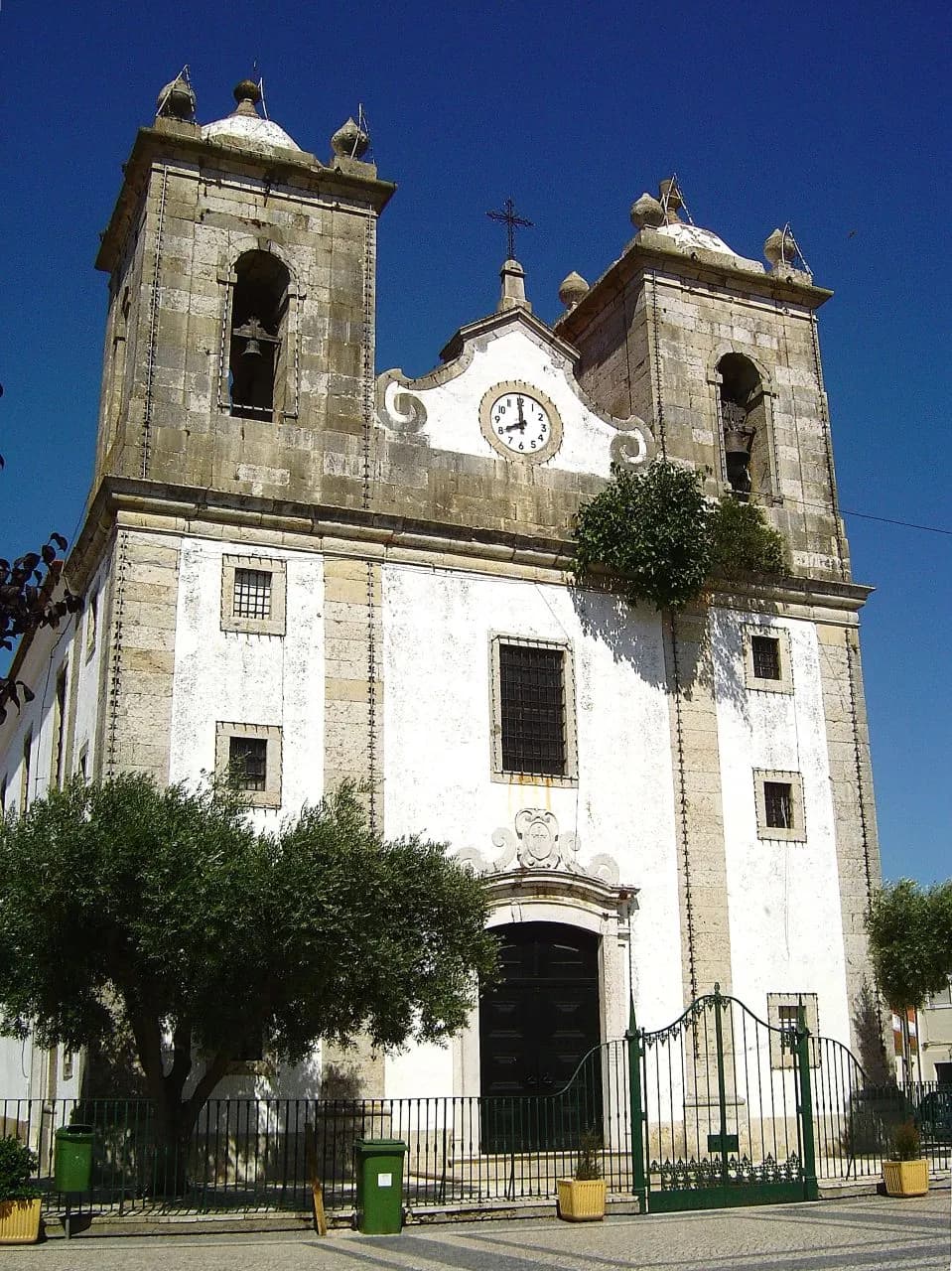
Why did so many buildings fail? Contemporary engineers blamed soft alluvial ground and building methods as much as the shaking. Almost everything in these towns, a local paper noted, was made of rammed earth, adobe or brick, often weighed down with heavy stone trim. The aftershocks went on for months. Teves-Costa and colleagues, combining Choffat and Bensaude's list with the daily bulletins in the Diário do Governo, count up to 183.
How many died
The figures are close but not identical. José de Oliveira Ferreira Diniz, whose study of the earthquake was finished in December 1909, wrote that 46 people died and 35 men, women and children were badly injured. The summary of the official report by Teves-Costa and colleagues gives 46 dead and 75 injured, with Benavente accounting for 30 of the dead and 35 of the injured. Fonseca and Vilanova, and Canora and colleagues, give 47 dead.
For an earthquake that left whole towns uninhabitable, that is a small toll. Writers at the time and seismologists since give the same reasons: it struck in late afternoon, when most of the people of these farming towns were still in the fields, and the area was thinly populated.
- Date and time
- Friday 23 April 1909, about 5:03 pm local time (17:39 to 17:40 GMT)
- Epicentre
- Near Benavente, about 40 km north-east of Lisbon
- Magnitude
- About Mw 6.0 to 6.2 in modern studies
- Highest intensity
- X on the Mercalli–Cancani scale (Choffat); IX on the Modified Mercalli scale (Moreira, 1984); X again in Teves-Costa and Batlló's 2011 revision
- Dead
- 46 or 47
- Injured
- 35 seriously injured (Ferreira Diniz) to 75 injured (Teves-Costa and colleagues)
- Aftershocks
- Up to 183 counted; the strongest on 4 May and 2 August 1909
The king, the soldiers and the collecting tins
Doctors and fire brigades reached the ruined towns quickly, mostly in private vehicles lent for the purpose; pharmacists sent help too, and the telegraph carried the news across the country. To stop looting, Benavente was guarded by a hundred police and soldiers of Caçadores 6, a light infantry unit, with thirty men of the 3rd Artillery. Some thefts happened anyway.
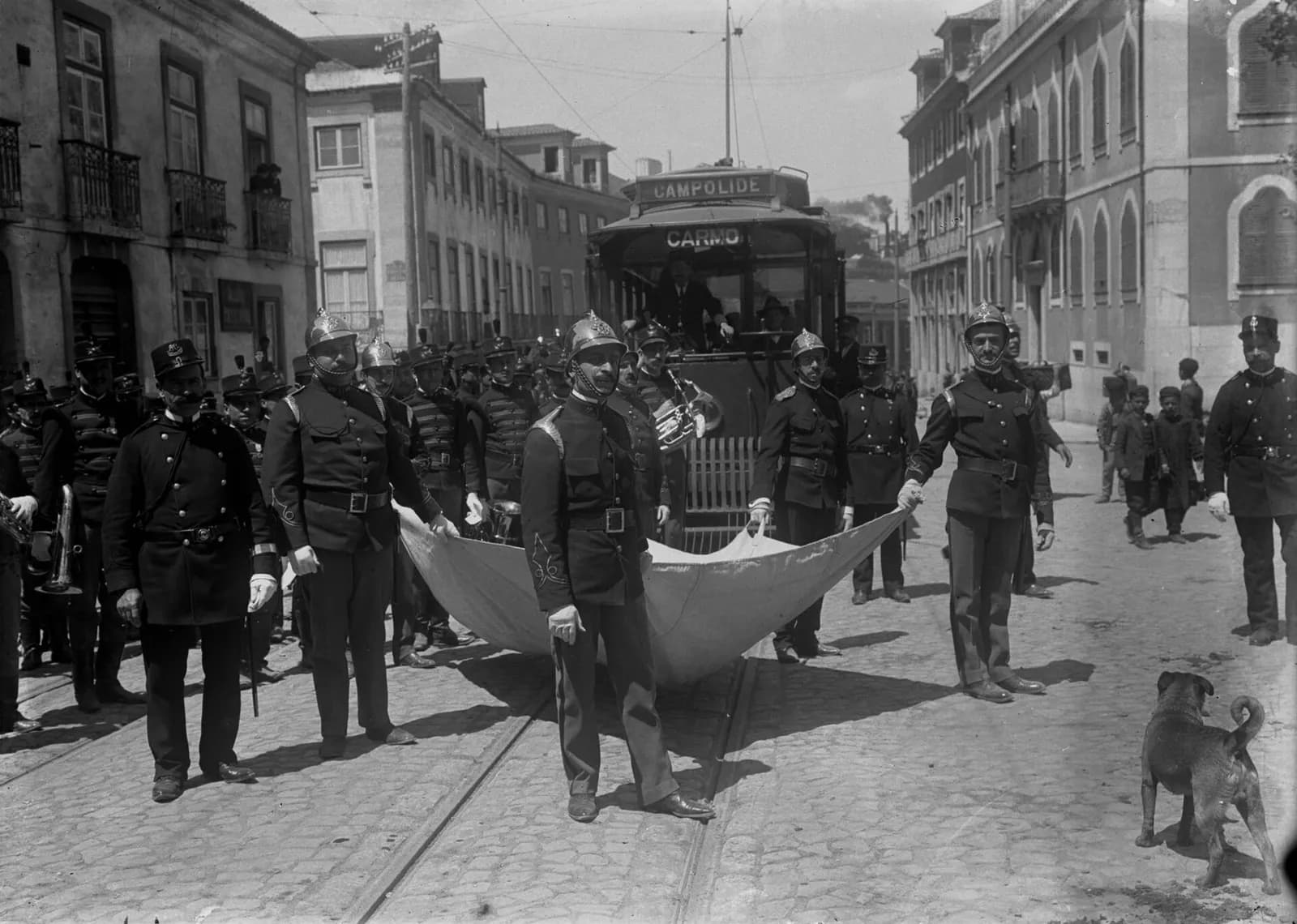
On 24 April, the day after the earthquake, Manuel II visited Benavente and Salvaterra de Magos and spoke to people who had lost their homes. He also chaired the national relief commission, the Grande Comissão Nacional de Socorros. The historian Maria Gabriela Mota Marques reads both as the king's attempt to show that the monarchy cared and was in charge.
The first job was shelter. Landowners and councils sent timber for huts: the farmers' guild and the council of Chamusca, upriver, sent twelve carpenters and a large load of wood. Others gave food, clothes and transport. The district governor of Santarém managed the funds, which were shared out at meetings in Lisbon, with most of the money going to the worst-hit towns.
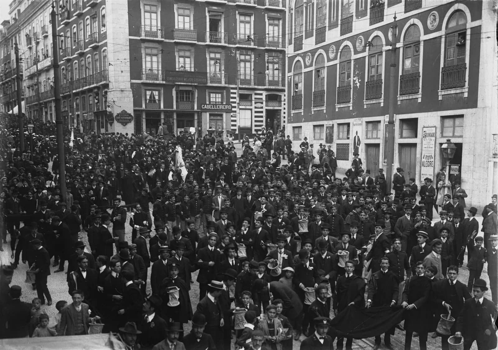
Most of the money came from ordinary people. Towns held bandos precatórios, street processions with collecting tins, as well as subscriptions, bullfights and charity evenings. Local papers printed who gave what, from the hundreds or thousands of réis given by landowners to the small sums of labourers. The Spanish government sent 100,000 pesetas. The ducal house of Cadaval helped Muge, and the landowner Luiz Sommer helped Coruche.
Not everyone came to help. Benavente, Salvaterra and Samora Correia became a Sunday outing for sightseers from Lisbon. And the old quarrel over religion flared. Some clergy preached that the earthquake was a punishment on atheists, freemasons and people who skipped mass; republican papers answered that a God of love would not kill poor innocents.
Rebuilding, slowly
The government moved quickly on paper. The Minister of Public Works named two commissions of engineers and public-works officials, by a ministerial order of 29 April printed in the civil engineers' journal; Fonseca and Vilanova put the appointment three days after the earthquake. One was to draw up rules for rebuilding the ruined towns and for new buildings across the country; the other was to study the earthquake itself.
Benavente's council proposed a national loan at 4.5% interest to rebuild the town and its villages, open to every council that joined. Owners would repay in twenty yearly instalments and pay no stamp duty or property tax for ten years if they rebuilt by December 1911. Azambuja asked the government for interest-free credit on similar terms. Mota Marques does not say whether either scheme went ahead.
Relief came in two stages: first huts, scattered to reduce the risk of epidemics in a district whose terrain and climate made it prone to disease, then new houses. Private donors added their own projects; a Lisbon firm set out to build a group of ten houses. Complaints followed. Some said aid went only to a small area, and that much of it paid for repairs to houses landlords rented out, not for the tenants.
“A cluster of wooden huts with zinc roofs, blackened and squalid, a disgrace exposed to the eyes of everyone who passes.”
By then the monarchy had fallen and Portugal was a republic, but four and a half years after the earthquake Benavente still had its camp of huts. Researchers on the SEISMIC-V project, which studies Portugal's traditional earthquake-resistant building, conclude that the official reconstruction plans of 1909, unlike Pombal's after 1755, do not seem to have been carried out in full. Because state aid was slow, most rebuilding was left to private owners.
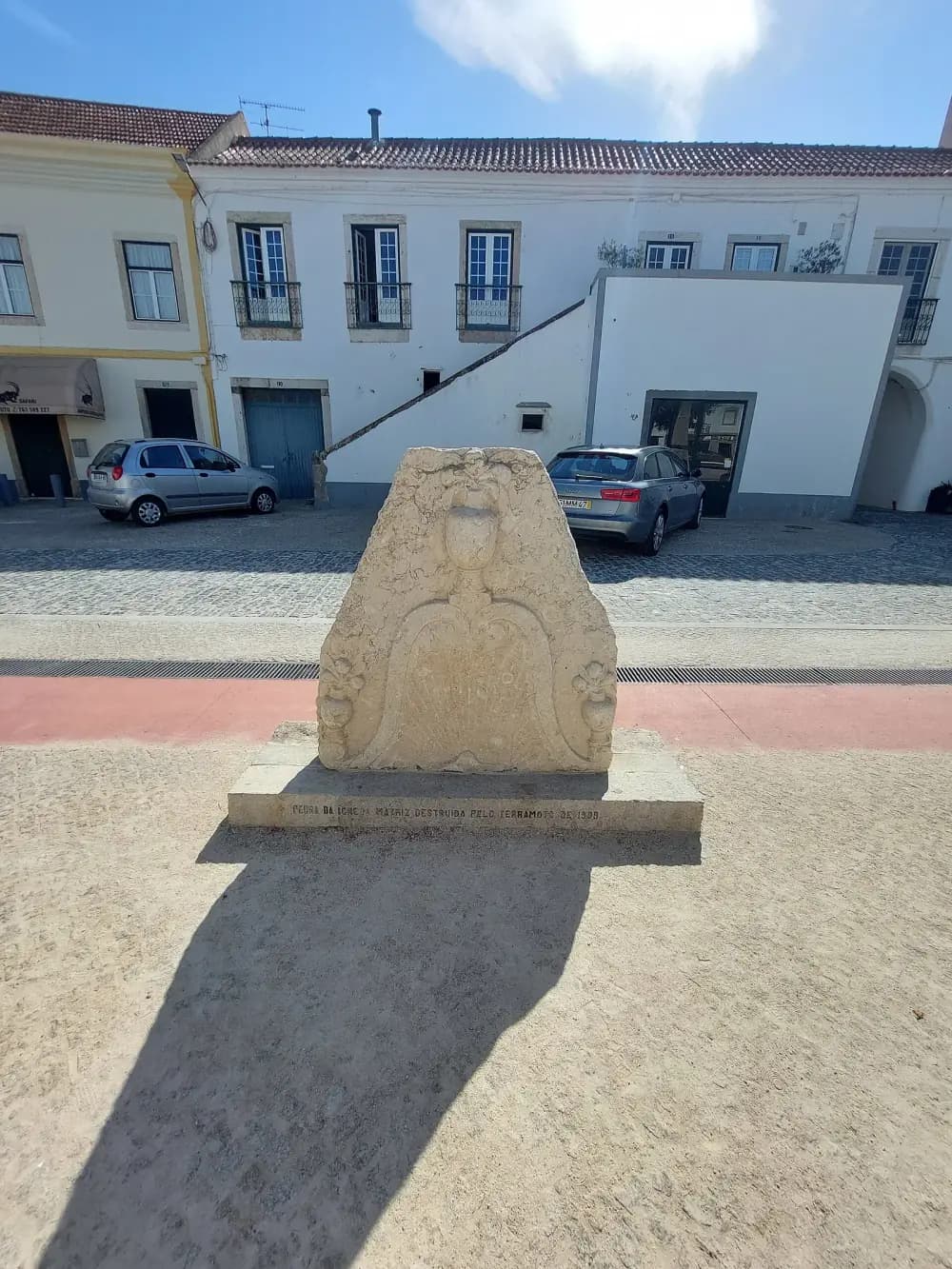
What they built looked much like what had fallen. The typical post-1909 house in Benavente is a long, single-storey building with a gabled roof. Its front wall, though, has an inner timber frame filled with stone or adobe, a simpler version of the gaiola pombalina, the wooden cage designed for Lisbon after 1755. Benavente's historic centre still has its old triangular plan, around the site of the destroyed parish church.
Late December 1908
Earthquake at Messina, Sicily; collections for its victims across the Ribatejo
23 April 1909, about 10 am
Underground rumbling heard around the epicentre
23 April 1909, about 5:03 pm
Main shock near Benavente
24 April 1909
Manuel II visits Benavente and Salvaterra de Magos
29 April 1909
Ministerial order names commissions for reconstruction and for scientific study
4 May 1909
Strong aftershock; sand and water spout again from the flood plain
June 1909
Student fundraising marches in Lisbon
2 August 1909
Largest aftershock, the only one recorded by seismographs
December 1909
Ferreira Diniz completes his study of the Coimbra seismogram
January 1910
Meeting on where to put Portugal's seismic stations
18 December 1911
Choffat presents the questionnaire results to Portugal's civil engineers
1912
Choffat and Bensaude's report published in Portuguese
November 1913
A local paper finds Benavente's wooden huts still standing
Measuring an earthquake without instruments
The scientific commission was led by Paul Choffat, a Swiss geologist working for the Portuguese Geological Services, with the petrographer Alfredo Bensaude, later the founder of Lisbon's Instituto Superior Técnico. Portugal had almost no instruments, so they did what the Swiss Seismological Commission did and asked people.
Questionnaires went out by post, with free return, to local officials, priests, teachers and postal and telegraph clerks. In Lisbon 25% of 240 came back; in the provinces 58% of 897, including 91 from telegraph operators. Choffat complained that answers were late, contradictory and written by people who had never paid attention to such things, at a time when about three-quarters of Portuguese could not read or write.
From the answers and newspaper reports Choffat drew a map of how strongly the earthquake was felt across the country. Together with his questionnaires, it showed that the shock had come from under the land, not from the sea as people had assumed for Portuguese earthquakes. Ferreira Diniz, working alone from the Coimbra seismogram, reached the same conclusion and traced the source along a line through Salvaterra, Benavente and just east of Samora.
Abroad the earthquake was well recorded. Within months the Spanish seismologist Navarro Neumann had gathered data from 51 stations, and researchers have since recovered 31 potentially useful seismograms from 14 stations, from Spain to Sweden. Those records let modern researchers work out its moment magnitude, a measure based on the physical properties of the earthquake.
How big was it? Magnitude estimates for the 1909 earthquake
magnitude
Estimates collected by Teves-Costa, Batlló and Cabral (2017). The first two came from the highest intensity alone (Antunes gave 7 1/3); Kárník's is a surface-wave magnitude from 13 stations' bulletins; Moreira's used one seismogram. Dineva (6.2), Teves-Costa (6.13) and Stich (6.0 ± 0.1) are moment magnitudes from digitised seismograms; Cabral's 6.0 ± 0.2 comes from intensity data. A catalogue value of 7.6, left out here, may come from a misapplied formula or a transcription error.
Show the data
| Estimated magnitude | |
|---|---|
| Antunes 1956 | 7.3 |
| Munuera 1963 | 6.6 |
| Kárník 1969 | 6.6 |
| Moreira 1991 | 6.7 |
| Dineva 2002 | 6.2 |
| Teves-Costa 2005 | 6.1 |
| Stich 2005 | 6 |
| Cabral 2013 | 6 |
The early figures, 6.6 to 7.3, were worked out from the worst damage, from station bulletins or from a single seismogram. The modern moment magnitudes, about 6.0 to 6.2, come from digitised seismograms and, in Cabral's case, the intensity map. Surface-wave magnitudes from the same old records come out a little higher, at 6.3 and 6.35, and Fonseca and Vilanova's 2010 paper has M 6.3 in its title. Even at 6.0 it was the largest earthquake on land in the Iberian Peninsula in the twentieth century.
The earthquake also pushed Portugal towards its own seismograph network. In January 1910 a meeting called by the king chose the Infante D. Luís observatory in Lisbon as the central station, and in 1910 a Mainka seismograph was installed at the Lisbon University observatory, followed by simple seismoscopes at three weather stations on the mainland and one in Madeira. A network covering the whole mainland came only after the earthquake of 28 February 1969, which has its own article.
Why it still matters
In 1909 the hardest-hit area had about 6,300 inhabitants. By 2017 the same towns had about 28,300, and the area holds infrastructure of national importance. Greater Lisbon, which shook in 1909 too, had almost 3 million people at the 2011 census.
Fonseca and Vilanova, writing a century after the event, judged that a repeat of 1909 would be a major hazard and that public awareness of it was low. Canora and colleagues note that faults inside plates often go quiet for long periods and then produce clusters of earthquakes, so a century of calm says little about what comes next.
FAQs
How many people died in the Benavente earthquake of 1909?
46 or 47, depending on the count. Ferreira Diniz recorded 46 dead and 35 badly injured; a summary of the official report gives 46 dead and 75 injured, 30 of the dead in Benavente; later studies give 47. The toll was low because many people were working in the fields.
How strong was the 1909 Benavente earthquake?
Modern studies based on old seismograms put it at about moment magnitude 6.0 to 6.2. Older estimates, from the damage or from a few early records, ran from 6.6 to 7.3. The shaking reached intensity X on the scale used at the time in Benavente, Samora Correia and Santo Estêvão.
Which fault caused the Benavente earthquake?
No one knows for sure. The rupture did not reach the surface, and the focal mechanism points to a buried reverse fault under the Tagus valley sediments. The leading candidates are the hidden southern part of the Azambuja fault or a structure linking it to the Vila Franca de Xira fault.
Could an earthquake like 1909 happen again near Lisbon?
Yes. The Lower Tagus Valley has produced damaging earthquakes in 1344, 1531 and 1909 and has the highest seismic hazard in western Iberia. Far more people now live in the 1909 epicentral area, about 28,300 against 6,300 then, and Greater Lisbon is close by.
On the timeline
Open the timelineNearby moments from regeneration and the last kings (1851–1910).
King Carlos I and Crown Prince Luís Filipe are assassinated by republican revolutionaries at Terreiro do Paço in Lisbon, in what became known as the Lisbon Regicide.
Manuel II takes his oath before the Cortes in Lisbon at his formal acclamation as King of Portugal, three months after inheriting the throne through the assassination of his father Carlos I and elder brother Luís Filipe. He would be Portugal's last king.
Birth in Funchal of Fernão de Ornelas, the lawyer who as president of the city council from 1935 to 1946 led a sweeping programme of public works that modernised Madeira's capital. Ousted after a clash with the island's governor, he was posthumously awarded Funchal's Medal of Honour in 2008.
The Benavente earthquake of 1909
An earthquake centred near Benavente strikes the Tagus valley at about 5 pm, wrecking much of Benavente, Samora Correia, Santo Estêvão and Salvaterra de Magos and killing 46 or 47 people. Aid poured in from across the country, but in 1913 Benavente still had a camp of wooden huts.
Club Sport Marítimo, one of Portugal's historic football clubs, is founded in Funchal on the island of Madeira; it would go on to win the national Campeonato de Portugal in 1926.
Miguel Bombarda, the psychiatrist who directed the Rilhafoles asylum and was one of the leaders of the republican conspiracy, is shot in his office by a former patient and dies that evening, hours before the uprising that proclaimed the Republic on 5 October.
The republican revolution breaks out in Lisbon. With the Palácio das Necessidades under threat of bombardment, King Manuel II withdraws to Mafra, and the following day he boards the royal yacht Amélia at Ericeira for exile, never to return.
Coming up in history
All long reads

11 sources
Archives, scholarship and reporting this article was checked against.
- 1
The Lower Tagus Valley (Portugal) earthquakes: Lisbon 26 January 1531 and Benavente 23 April 1909 (Paula Teves-Costa, Josep Batlló and João Cabral)Física de la Tierra 29 (2017), Universidad Complutense de Madrid
- 2
Quando as águas e a terra se revoltam. Calamidades naturais no Ribatejo: as cheias e os terramotos (1901–1920) (Maria Gabriela Mota Marques)Revista Portuguesa de História, vol. XXXIV (2000), Universidade de Coimbra
- 3
The 23 April 1909 Benavente (Portugal) M 6.3 earthquake (J. F. B. D. Fonseca and S. P. Vilanova)Seismological Research Letters 81 (3), 2010, Historical Seismologist column, Seismological Society of America
- 4
The 1909 Benavente (Portugal) earthquake: search for the source (João Cabral and others), Natural Hazards 69 (2), 2013, pp. 1211–1227Repositório do LNEG, Laboratório Nacional de Energia e Geologia (abstract and first page)
- 5
- 6
Evidence of Surface Rupture Associated With Historical Earthquakes in the Lower Tagus Valley, Portugal (Carolina Canora and others)Frontiers in Earth Science 9 (2021), article 620778
- 7
PR1 Rota das Lezírias: walking and cycling route between Benavente and Samora Correia (leaflet)Câmara Municipal de Benavente, 2017
- 8
Minister Bryan to the Secretary of State, Lisbon, 3 February 1908 (No. 375)Office of the Historian, US Department of State: Papers Relating to the Foreign Relations of the United States, 1908, document 670
- 9
Earthquake Magnitude, Energy Release, and Shaking IntensityUS Geological Survey, Earthquake Hazards Program
- 10
Portuguese Historical SeismicitySEISMIC-V: Local seismic culture in Portugal, Escola Superior Gallaecia
- 11
Image credits
- Lisbon firemen collect money in an outstretched sheet for the victims of the Benavente earthquake, in the Rua da Escola Politécnica by the Largo de São Mamede, April 1909. Joshua Benoliel, Public domain, via Wikimedia Commons.
- The eighteenth-century parish church of Nossa Senhora da Oliveira in Samora Correia, photographed in 2006. In 1909 it stayed standing but was badly cracked, while most of the mud and stone houses around it fell. Vitor Oliveira from Torres Vedras, Portugal, CC BY-SA 2.0, via Wikimedia Commons.
- Students on a fundraising march for the earthquake victims in the Rua da Misericórdia, Lisbon, in June 1909. The photograph appeared in Ilustração Portuguesa on 14 June 1909. Joshua Benoliel, Public domain, via Wikimedia Commons.
- A carved stone from Benavente's parish church, destroyed in the 1909 earthquake, on a plinth in the garden of the Praça da República, photographed in 2023. The base is inscribed “Pedra da Igreja Matriz destruída pelo terramoto de 1909”. Threeohsix, CC BY-SA 4.0, via Wikimedia Commons.
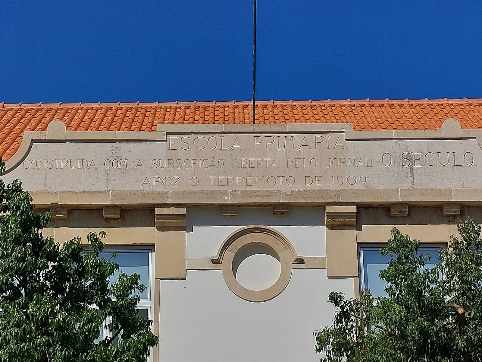
- The primary school at Salvaterra de Magos, photographed in 2023. Its frieze records that it was built with the subscription opened by the Lisbon newspaper O Século after the earthquake of 1909. Threeohsix, CC BY-SA 4.0, via Wikimedia Commons.