

Inter caetera, 1493: the pope's line that led to Tordesillas
A papal bull dated 4 May 1493 gave Castile every unclaimed land beyond a line 100 leagues west of the Azores and Cape Verde. João II would not accept it, and within a year the two crowns had drawn their own line at Tordesillas.
At a glance
- Inter caetera is a bull of Pope Alexander VI dated 4 May 1493. It gave Ferdinand and Isabella of Castile all lands west of a pole-to-pole line 100 leagues beyond any of the Azores or Cape Verde islands.
- The bull was antedated: the papal chancery issued it in June 1493, after a first Inter caetera dated 3 May had given Castile only the lands its envoys found.
- It did not name Portugal or give it anything. It excepted only lands that another Christian prince already held at Christmas 1492, and it barred anyone from sailing beyond the line without a Castilian licence.
- João II of Portugal said the line left his ships too little sea. By the Treaty of Tordesillas, signed on 7 June 1494, Castile agreed to move it to 370 leagues west of the Cape Verde islands.
- The new line was never surveyed. It put the eastern bulge of South America on Portugal's side, and Spain and Portugal argued over where it ran, and where it met the far side of the world, until 1750.
A date written in June
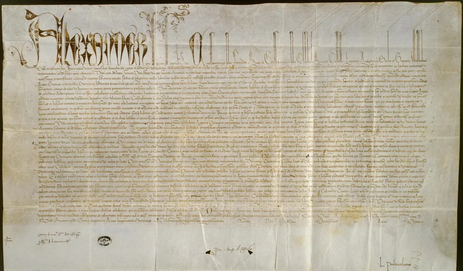
The parchment ends the way papal bulls did: given at Rome, at St Peter's, in the year of the Incarnation 1493, “quarto nonas Maii”, the fourth day of May, in the first year of the pontificate. Below the text, in the left margin, a chancery clerk wrote “Jun.”. The bull dated 4 May went out of the papal offices several weeks later, in June.
The Encyclopaedia of Portuguese Expansion puts its completion at 28 June 1493. Nobody knows why it was antedated. What it said was new: from the Arctic pole to the Antarctic pole, a line was to run 100 leagues west and south of any of the islands “commonly known as the Azores and Cape Verde”, and every island and mainland beyond it, found or still to be found, was to belong to the kings of Castile and León.
Pope Alexander VI addressed it to Ferdinand and Isabella of Castile and Aragon. It bears a date seven weeks after Christopher Columbus landed back in Spain from the Caribbean. Portugal, which had spent most of the century pushing down the coast of Africa, read it as a threat. A year of quarrelling ended with the two crowns drawing a line of their own at Tordesillas, which is the one that left Brazil to Portugal.
What you need to know first
A bull is a solemn papal letter, named after its lead seal and known by its first Latin words. Portugal had collected several confirming its African voyages. Romanus Pontifex in 1455 and an earlier Inter caetera, issued by Calixtus III in 1456, reserved to Portugal the trade and conquest of the coast from Cape Bojador through Guinea, “as far as to the Indians”.
Castile went on claiming Guinea until the Treaty of Alcáçovas of 1479, in which it left Portugal Guinea, Madeira, the Azores and the Cape Verde islands and kept the Canaries for itself. Pope Sixtus IV confirmed the deal in 1481 with the bull Aeterni regis. Every one of these texts was written with Africa in mind.
Then Columbus came back from the west. Storms drove him into the Tagus in March 1493 on his way home, and João II told him the islands fell within Portugal's lordship of Guinea; that meeting has its own article. The king prepared a fleet under Francisco de Almeida, and Ferdinand and Isabella, warned of it, asked him to hold it back. They had already sent word to Rome.
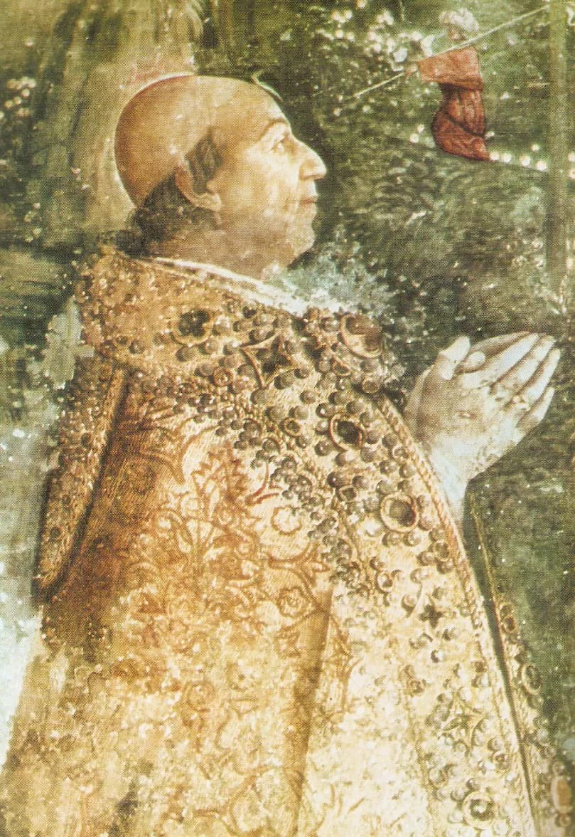
The pope they turned to was Rodrigo Borgia, born at Xàtiva, near Valencia, in 1431, who had run the papal chancery as vice-chancellor for decades. He was proclaimed pope on the morning of 11 August 1492 and took the name Alexander VI. Davenport describes him as a friend of King Ferdinand, and the bulls he issued for Castile in 1493 were highly favourable to it.
Four bulls in five months
Alexander issued a series of bulls, and the dates on them mislead. The first Inter caetera, dated 3 May, gave Castile the lands its envoys had found and would find, if no Christian ruler held them, and it promised that no right already granted to any Christian prince was being taken away. That saving clause protected Portugal's earlier grants.
Two later bulls replaced it. Eximiae devotionis, also dated 3 May but issued in July, gave Castile in its discoveries the same privileges Portugal held in Africa. The second Inter caetera, dated 4 May and issued in June, drew the line. It dropped the general safeguard for Portugal and kept only an exception for lands that a Christian king actually possessed by Christmas 1492.
| Bull | Date it bears | Actually issued | What it did |
|---|---|---|---|
| Inter caetera (first) | 3 May 1493 | No later date given | Gave Castile the lands found by its envoys and not held by Christians; kept Portugal's earlier rights safe |
| Eximiae devotionis | 3 May 1493 | July 1493 | Gave Castile, in its discoveries, the privileges Portugal held in Africa |
| Inter caetera (second) | 4 May 1493 | June 1493 (28 June, according to Ferreira) | Drew a line 100 leagues west of the Azores and Cape Verde and gave Castile all lands beyond it |
| Dudum siquidem | 26 September 1493 | September 1493 | Extended Castile's grant to lands in the Indies reached by sailing west; revoked earlier grants to Portugal over lands it did not actually hold |
Davenport, following Vander Linden, says the 4 May bull was issued in June and Eximiae devotionis in July; he gives no separate issue date for the first Inter caetera. The date of 28 June comes from José Luís Ferreira in the Encyclopaedia of Portuguese Expansion.
“all islands and mainlands found and to be found, discovered and to be discovered towards the west and south, by drawing and establishing a line from the Arctic pole, namely the north, to the Antarctic pole, namely the south, no matter whether the said mainlands and islands are found and to be found in the direction of India or towards any other quarter, the said line to be distant one hundred leagues towards the west and south from any of the islands commonly known as the Azores and Cape Verde.”
The bull went further than a grant of land. Under pain of excommunication incurred automatically, it forbade anyone of any rank, “even imperial and royal”, to sail beyond the line for trade or any other reason without a licence from the Castilian monarchs. It also ordered them to send “worthy, God-fearing, learned” men to teach the inhabitants the Catholic faith.
The figure of 100 leagues probably came from Columbus. Davenport calls it highly probable, the Encyclopaedia of Portuguese Expansion says he suggested it, and Fernando Columbus later wrote that his father had. Columbus believed that about 100 leagues west of the Azores the ocean itself changed, and he said so in a letter to the monarchs in 1498.
“When I sailed from Spain to the Indies, I found that as soon as I had passed a hundred leagues westward of the Azores, there was a very great change in the sky and the stars, in the temperature of the air and in the water of the sea.”
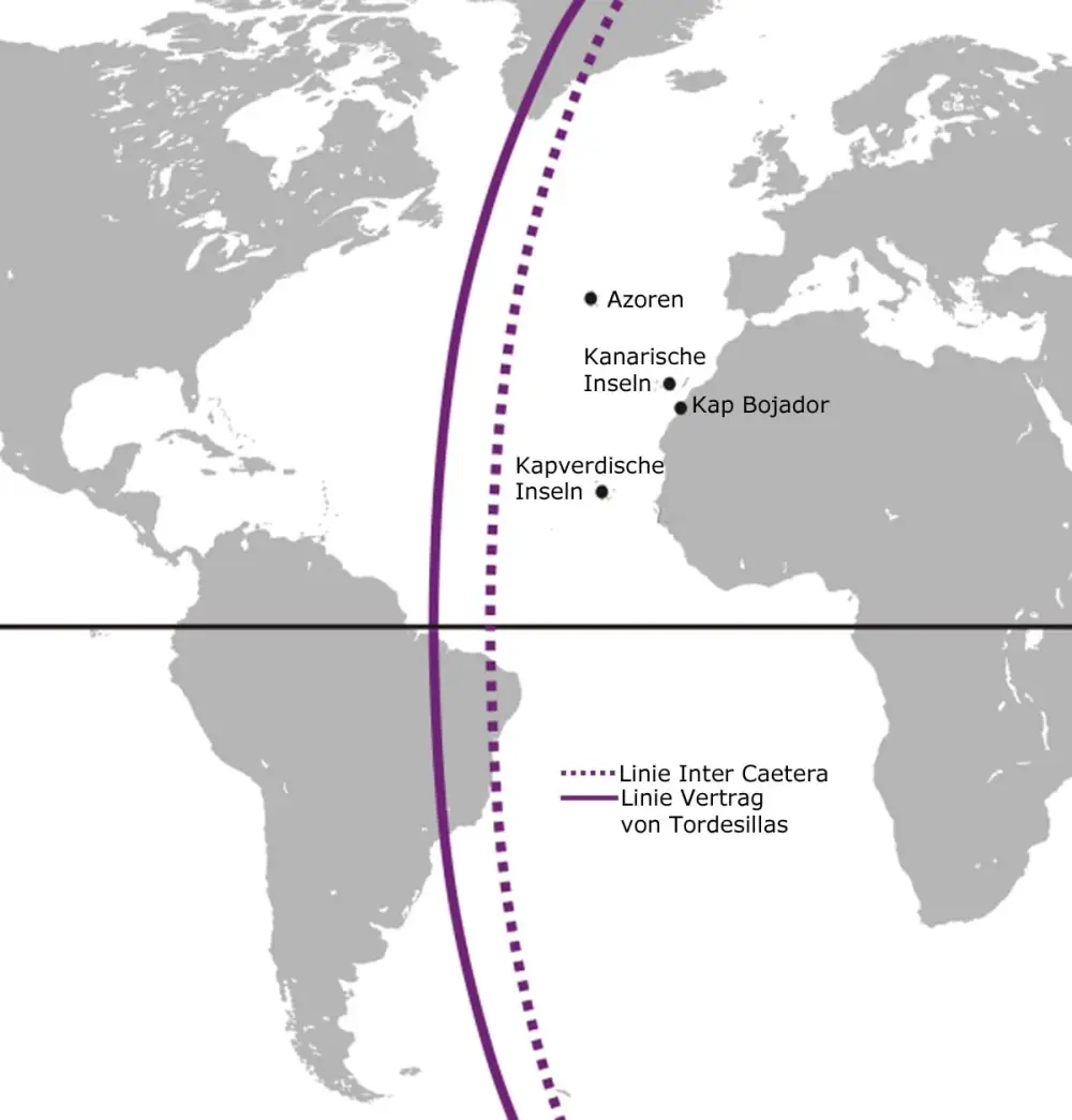
He had also noticed his compass needles swing from pointing east of north to west of north there, and thought he had crossed into a new region of the world. How long a league was is less certain. K. Kretschmer, in a German history of the discovery of America published in 1892, took it as four Roman miles of about 1,480 metres each, so roughly 5.9 kilometres. Counting from Santo Antão, the westernmost Cape Verde island, he put the papal line at about 31 degrees west.
Portugal objects
João II had already set out his own idea of a boundary. His envoy Rui de Sande asked the Castilian monarchs to keep their subjects from fishing south of Cape Bojador and to make the parallel of the Canaries the limit, with the sea south of it left to Portugal. A line of latitude would have left Portugal everything south of the Canaries, however far west.
The papal line was a meridian instead, and a close one. Portuguese ships sailed to the Azores and Cape Verde all the time, Davenport explains, and a frontier only 100 leagues out left them too little sea. Dawson reads the words “west and south” in the bull as aimed squarely at Portugal's claim that everything south of Bojador was its own, whichever way it lay.
The bull of 26 September, Dudum siquidem, made things worse for Lisbon. It said that if Castilian ships sailing west reached lands in the east that belonged to India, those lands were Castile's too, and it revoked earlier papal grants to Portugal over lands it did not actually hold. Portugal had not yet reached India; Vasco da Gama got there only in 1498.
João answered with diplomacy in Castile. His envoys Pero Dias and Rui de Pina reached Barcelona in August 1493 and came home with nothing; Pina, who later wrote the king's chronicle, blamed Castile for stalling until its second fleet sent news. A grand Castilian embassy to Lisbon in November achieved no more. In March 1494 the talks moved to Medina del Campo.
There Portugal asked for a meridian much further west, halfway between the Cape Verde islands and the lands Columbus had found. The Aragonese chronicler Jerónimo Zurita, as Davenport summarises him, said João “was certain that within those limits famous lands and things must be found”. The Encyclopaedia of Portuguese Expansion gives two reasons. Ships returning from the Cape of Good Hope had to swing far out into the Atlantic, and the king may also have known or suspected land in the south-west.
March 1493
Columbus in Portugal
João II says the new islands fall within Portugal's lordship of Guinea.
2 May 1493
Castile hears of a Portuguese fleet
Ferdinand and Isabella write to the Duke of Medina-Sidonia about João's preparations.
3 and 4 May 1493
Dates on the first bulls
Inter caetera of 3 May; Eximiae devotionis, also dated 3 May; Inter caetera of 4 May, actually issued in June.
Mid-August 1493
Talks at Barcelona
Pero Dias and Rui de Pina meet the Catholic Monarchs. No agreement.
26 September 1493
Dudum siquidem
Castile's grant is extended to lands in the Indies reached by sailing west.
November 1493
Castilian embassy in Lisbon
Garcia de Carvajal and Pedro de Ayala achieve nothing.
March 1494
Talks move to Medina del Campo
Rui de Sousa, his son João de Sousa and Aires de Almada ask for a line further west.
7 June 1494
Treaty of Tordesillas
The line moves to 370 leagues west of the Cape Verde islands.
The line moves: Tordesillas, 7 June 1494
At Tordesillas, near Valladolid, the Castilian representatives Enrique Enríquez, Gutierre de Cárdenas and Dr Rodrigo Maldonado signed with João's three envoys on 7 June 1494. The pope was not a party. The two crowns agreed a new meridian 370 leagues west of the Cape Verde islands, everything east of it to Portugal and everything west to Castile, and asked Rome only to confirm it.
“a boundary or straight line be determined and drawn north and south, from pole to pole, on the said ocean sea, from the Arctic to the Antarctic pole. This boundary or line shall be drawn straight, as aforesaid, at a distance of three hundred and seventy leagues west of the Cape Verde Islands.”
- Signed
- 7 June 1494, at Tordesillas
- Line
- Pole to pole, 370 leagues west of the Cape Verde islands
- Survey
- Within ten months, one or two caravels from each side were to meet at Grand Canary and fix the line together
- Passage
- Castilian ships could cross Portugal's waters on direct courses to their own side
- Lands Castile found by 20 June 1494
- Portugal's if within the first 250 leagues of the 370; Castile's if in the last 120
- Ratified
- By Ferdinand and Isabella at Arévalo, 2 July 1494; by João II at Setúbal, 5 September 1494
- Papal confirmation
- Bull Ea quae of Julius II, 24 January 1506
Each crown kept the other's signed copy. The ratification of Ferdinand and Isabella, signed at Arévalo on 2 July 1494, is in the Torre do Tombo, Portugal's national archive in Lisbon, under the reference PT/TT/GAV/17/2/24. João II's, signed at Setúbal on 5 September, is in the Archivo General de Indias in Seville. In 2007 UNESCO added the treaty to its Memory of the World register on a joint Portuguese and Spanish nomination.
Where was the line?
Nobody knew. The caravels were never sent. On 7 May 1495 Ferdinand and Isabella signed a further agreement for experts to meet on the border and settle how to measure the line, and that was not carried out either. The treaty did not say which Cape Verde island to count from or how many leagues made a degree, and Portugal later chose whichever island suited it at the time.
In 1495 the cosmographer Jaime Ferrer, of Blanes, advised the Castilian monarchs to count from Fogo, the central island, and reckoned the 370 leagues at 18 degrees. Writing in 1897, the historian Henry Harrisse converted Ferrer's line and later ones onto a modern map. They run from about 42 to 50 degrees west, on the north coast of Brazil, and all but one fall east of both mouths of the Amazon.
Where the line fell, by different reckonings
degrees west of Greenwich
The papal line of 1493 as calculated by Konrad Kretschmer, counting 100 leagues from Santo Antão (Davenport, note to the bull of 4 May). The other bars are Harrisse's 1897 reconstructions of where each authority's Tordesillas line falls on a modern map: Ferrer 45°37′, Cantino 42°30′, Enciso 45°38′, the Badajoz experts 46°36′, Ribeiro 49°45′ and Oviedo's reading of the Seville master chart 45°17′, shown here in decimal degrees.
Show the data
| Longitude of the line | |
|---|---|
| Inter caetera, 1493 (Kretschmer) | 31 |
| Ferrer, 1495 | 45.6 |
| Cantino map, 1502 | 42.5 |
| Enciso, 1518 | 45.6 |
| Badajoz experts, 1524 | 46.6 |
| Ribeiro, 1529 | 49.8 |
| Oviedo, 1545 | 45.3 |
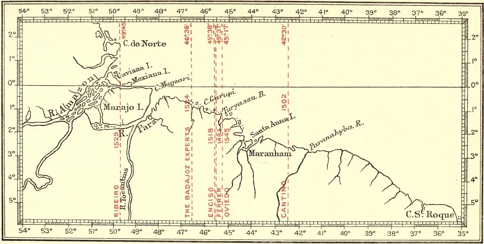
Maps did not settle it. The oldest surviving map showing the line is the Cantino planisphere, copied in Lisbon in 1502. On Portuguese and Spanish charts of 1519, 1527 and 1529 it doubled as the prime meridian. Harrisse reckoned that charts such as those of Diogo Ribeiro, Charles V's chief cartographer, gave Portugal about 520 miles more longitude than Ferrer's reckoning of 1495.
How the line was used
The line soon had something to divide. On 22 April 1500 the India fleet of Pedro Álvares Cabral reached the coast now called Brazil, and Cabral claimed it for Portugal. Vicente Yáñez Pinzón had taken possession of part of that coast for Castile about three months earlier, but it lay on Portugal's side of the line. In 1500 and 1501 Gaspar Corte-Real sailed to lands in the north-west Atlantic that the Portuguese also placed on their side, and in 1506, at Manuel's request, Pope Julius II confirmed the treaty.
Other kings ignored it. Henry VII of England sent John Cabot west across it, Francis I of France sent Giovanni da Verrazzano, and both countries later founded claims in North America on those voyages. In Dawson's view the bull bound Spain and Portugal “as regards each other”; how far it bound anyone else he left aside.
The harder question was where the line ran on the other side of the globe. Portuguese ships reached the Moluccas, the clove islands of eastern Indonesia, in 1512, and in 1514 Pope Leo X granted Portugal whatever it found sailing east, even beyond the halfway point. The question became practical, Dawson notes, when the expedition of Fernão de Magalhães (Magellan), sailing west for Castile, reached the Philippines. A conference of experts at Badajoz in 1524 failed to agree.
Money settled it. By the Treaty of Zaragoza of 22 April 1529, the Emperor Charles V pledged to Portugal, for 350,000 ducats, all his rights in the Moluccas and in the lands and seas as far east as a meridian 17 degrees east of them. On that reckoning the Philippines fell on Portugal's side, but Spain colonised them anyway. Portugal protested in the 1540s and in 1568, and the dispute went quiet only in 1580, when the king of Spain also became king of Portugal.
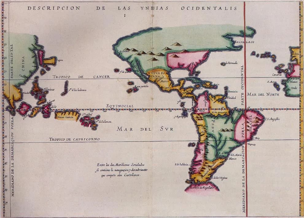
On paper the line lasted until the Treaty of Madrid of 1750, which annulled the demarcation lines of Alexander VI's bull, Tordesillas and Zaragoza; it let Spain keep the Philippines and denied Portugal any refund of the 1529 price. The border agreed at San Ildefonso in 1777 has its own article.
Why it still matters
Brazil is the plainest result. UNESCO's register says that moving the line produced Brazil, since the country's eastern side fell in the Portuguese zone. The Encyclopaedia of Portuguese Expansion adds that the treaties of Madrid and San Ildefonso, which replaced Tordesillas, drew borders between Brazil and its Spanish-speaking neighbours that largely survive today.
The bull itself has had a longer and harsher afterlife. Some scholars trace the legal “doctrine of discovery”, which courts in several countries used to limit the land rights of indigenous peoples, to papal grants such as Romanus Pontifex and Inter caetera. On 30 March 2023 two Vatican departments answered that argument in a joint statement.
“The “doctrine of discovery” is not part of the teaching of the Catholic Church. Historical research clearly demonstrates that the papal documents in question, written in a specific historical period and linked to political questions, have never been considered expressions of the Catholic faith.”
The same statement admitted that the bulls “did not adequately reflect the equal dignity and rights of indigenous peoples” and that colonial powers had used them to justify immoral acts. Closer to home, a pope's line drawn for Castile pushed João II into the negotiation that gave his successors the coast where Cabral landed six years later.
FAQs
What did the bull Inter caetera of 4 May 1493 say?
It gave Ferdinand and Isabella of Castile, and their successors, all islands and mainlands west of a pole-to-pole line 100 leagues west and south of any of the Azores or Cape Verde islands, unless a Christian prince already held them at Christmas 1492. It forbade anyone else to sail there without a Castilian licence, on pain of excommunication.
Was Inter caetera really issued on 4 May 1493?
No. The bull bears that date, but the papal chancery issued it in June 1493; José Luís Ferreira gives 28 June. An earlier bull with the same opening words, dated 3 May, gave Castile its discoveries without drawing any line.
Did Pope Alexander VI divide the world between Spain and Portugal?
Not directly. His bull drew a line in the Atlantic in Castile's favour and did not mention Portugal. The division into a Spanish and a Portuguese zone came from the two crowns' own Treaty of Tordesillas of 1494, which moved the line to 370 leagues west of the Cape Verde islands. A pope confirmed it only in 1506.
What is the difference between the papal line and the Tordesillas line?
The papal line of 1493 ran 100 leagues west of any of the Azores or Cape Verde islands; Kretschmer, counting from the Cape Verde islands, put it at about 31 degrees west. The Tordesillas line of 1494 ran 370 leagues west of the Cape Verde islands, between about 42 and 50 degrees west on the reckonings Harrisse compared, and crossed the eastern bulge of South America, which is why Brazil became Portuguese.
Is Inter caetera still valid?
Spain and Portugal annulled the demarcation lines of the bull and of the treaties of Tordesillas and Zaragoza in the Treaty of Madrid of 1750. In 2023 the Vatican said the doctrine of discovery that some scholars trace to such bulls is not Catholic teaching and repudiated it.
On the timeline
Open the timelineNearby moments from the age of discoveries (1415–1580).
Death at age 16 of Prince Afonso, only legitimate son and heir of King João II and Queen Eleanor, after a fall from a horse on the banks of the Tagus near Santarém. The tragedy ends the direct Avis succession and sets in motion the dynastic chain that, three generations later, will deliver Portugal into the hands of the Habsburgs.
Ferdinand and Isabella of Spain sign the Alhambra Decree, ordering the expulsion of all Jews who refuse to convert. Tens of thousands of Spanish Jews flee to Portugal, significantly increasing the Jewish population until Manuel I's own expulsion edict in 1496.
Christopher Columbus, returning from his first voyage to the Americas, is driven by a storm into the Tagus and anchors at Restelo, near Lisbon. João II receives him on 9 March and claims the new lands for Portugal, a dispute settled by the Treaty of Tordesillas.
Inter caetera, 1493
Pope Alexander VI's bull 'Inter caetera', dated this day but issued in June, grants Castile all lands west of a line 100 leagues beyond the Azores and Cape Verde islands. Portugal's objections to the line lead to the Treaty of Tordesillas the following year.
The Treaty of Tordesillas is signed between Portugal and Spain, dividing newly discovered lands outside Europe along a meridian 370 leagues west of the Cape Verde islands. Portuguese diplomacy secures the shift of the line westwards from the 100 leagues set by the papal bull of 1493, a decision that would give Portugal its claim to Brazil after Cabral's 1500 landfall.
Birth of João Cidade (later Saint John of God / São João de Deus) in Montemor-o-Novo. He would found the Brothers Hospitallers religious order and become the patron saint of hospitals, the sick, and healthcare workers.
João II, 'o Príncipe Perfeito', dies at Alvor in the Algarve aged 40. The king who broke the power of the great nobles and drove exploration down the African coast towards India was succeeded by his cousin and brother-in-law Manuel I.
Coming up in history
All long reads 6 May 1908Manuel II swears his oath: the acclamation of Portugal's last king, 1908
 7 May 1487Pêro da Covilhã's secret journey to India and Ethiopia, 1487
 8 May 1782Questioned, condemned, spared: the Marquis of Pombal's last years, 1777–1782
 9 May 1386The Treaty of Windsor, 1386: Portugal and England's perpetual league
10 sources
Archives, scholarship and reporting this article was checked against.
- 1
European Treaties bearing on the History of the United States and its Dependencies to 1648, vol. IFrances Gardiner Davenport (ed.), Carnegie Institution of Washington, 1917 (Internet Archive)
- 2
Tordesillas Treaty (José Luís Ferreira)Encyclopaedia of Portuguese Expansion, NOVA FCSH, 2009
- 3
- 4
- 5
- 6
Treaty of TordesillasUNESCO Memory of the World Register (nominated by Portugal and Spain, inscribed 2007)
- 7
Joint Statement of the Dicasteries for Culture and Education and for Promoting Integral Human Development on the “Doctrine of Discovery”Holy See Press Office, 30 March 2023
- 8
Bulls and Briefs (Herbert Thurston)The Catholic Encyclopedia, vol. 3 (1908), New Advent
- 9
- 10
Documentos fundamentais da história do Brasil no Arquivo Nacional Torre do Tombo (list for the CPLP)Direção-Geral do Livro, dos Arquivos e das Bibliotecas (DGLAB), 2014
Image credits
- The bull Inter caetera dated 4 May 1493, the parchment sent to Ferdinand and Isabella and now in the Archivo General de Indias in Seville. The chancery notes below the text include “Jun.”, for June, when it was actually issued. Unknown author, Public domain, via Wikimedia Commons.
- Alexander VI at prayer, a detail of Pinturicchio's fresco of the Resurrection in the Borgia Apartments of the Vatican, painted between 1492 and 1494. Pinturicchio, Public domain, via Wikimedia Commons.
- A modern sketch of the two lines, labelled in German: the dotted line of Inter caetera (1493) and the solid line of the Treaty of Tordesillas (1494). Here the papal line clips the eastern tip of Brazil; counted from the Cape Verde islands, Kretschmer put it at about 31 degrees west, in open sea. Neither line could be fixed this precisely at the time. Koppchen, CC BY 3.0, via Wikimedia Commons.
- Henry Harrisse's chart of 1897 showing where each early authority's Tordesillas line would meet the coast of Brazil, from Ribeiro (1529) near the Amazon in the west to the Cantino map (1502) in the east. Henry Harrisse (c.1830–1910), Public domain, via Wikimedia Commons.
- Antonio de Herrera's map of the Spanish Indies, in a print dated 1622, marks two meridians of demarcation, one through Brazil and one in East Asia. The note in the South Pacific says that between them lies the navigation and discovery that belongs to the Castilians. Map by Antonio de Herrera y Tordesillas, Public domain, via Wikimedia Commons.