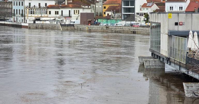
Civil Protection raises state of readiness for bad weather to maximum level
Level 4, the highest on the scale, 'means 100% of Civil Protection agents' capacity is available', ANEPC emphasises.

Latest news and stories about weather alert in infrastructure in Portugal for expats and residents.
This page has only 2 stories and is not indexed by search engines.
Level 4, the highest on the scale, 'means 100% of Civil Protection agents' capacity is available', ANEPC emphasises.

Ten districts of mainland Portugal will be under an orange warning, the second-highest, from Monday to Wednesday because of rough seas, the Portuguese Institute for the Sea and Atmosphere (IPMA) announced today.
The Sub-Regional Commander for Emergency and Civil Protection of Alentejo Litoral also warned that “the night from Sunday to Monday will be worse”.

Weather update at 17:00: next week is forecast to bring heavy rain across the region.

Civil Protection, the Portuguese Environment Agency and IPMA warn of “rapid flooding in urban areas” in the coming days

Flows are approaching 3,000 cubic metres, a level which, says Civil Protection, 'sets off the alerts' due to rain forecast for the next few days.

A total of 2,264 emergency personnel were involved in the rescue operations, supported by 677 vehicles.

The next few days are unlikely to bring an immediate repeat of Kristin's severity, but they could lay the groundwork for new problems, especially if the low-pressure system forecast for the 8th confirms a more direct track over Portugal.

The meteorological institute has issued red warnings for extremely rough seas — with swells up to 15 metres — for Porto, Braga and Viana do Castelo overnight from Friday into Saturday, while the broader west coast remains on orange. The three districts will be downgraded to an orange warning between 03:00 and 18:00 on Saturday. Authorities warn of significant risk to maritime operations, coastal infrastructure and public safety; residents and mariners are advised to avoid the shore, follow local advisories and expect disruptions to ferry services and port activity.

Ten coastal districts on the mainland are under a red alert today until 21:00 due to rough sea conditions, with waves that may reach up to 14 metres, the Portuguese Institute for the Sea and Atmosphere (IPMA) announced.

Vasco Oliveira provides an update on the incidents in Águeda, where the passage of the low-pressure system Kristin was milder. Over the next few hours calmer conditions are forecast, but the area remains on alert.

Ângela Lourenço, from the Portuguese Institute for the Sea and the Atmosphere (IPMA), warns that heavy and persistent rain will continue in mainland Portugal.

Low-pressure system Kristin is causing strong winds.

Home News Where did Storm Kristin bring the strongest wind gust? Where did Storm Kristin bring the strongest wind gust?

The city of Lisbon recorded, between 21:00 on Monday and 13:00 today, a total of 56 incidents related to adverse weather, mainly fallen trees, the director of the Municipal Civil Protection Service said.

As of 06:00, the low-pressure system named Joseph has prompted over 1,100 reported incidents; emergency services are responding.

The Portuguese Environment Agency (APA) warned on Monday of a flood risk during the week, particularly affecting areas north of the Mondego River and the Tagus basin.

IPMA upgraded the warning to red for the islands in the Western and Central groups of the Azores because of rough seas, with waves forecast up to 10 metres high.

The Portuguese Environment Agency warns of a risk of flooding, especially on Monday and Tuesday. Soils are saturated; some areas were hit by snow that will melt, and the rain continues.

Portuguese Environment Agency APA is warning of the risk of flooding this week, particularly in the region north of the Mondego River and in the Tejo river basin. Today and The post Warning: rivers now posing flood risk in multiple areas appeared first on Portugal Resident.

Snow accumulated in the mountain ranges of the central inland region, together with heavy rainfall in recent days and the heavy precipitation expected on Monday and Tuesday, are increasing the risk of flooding.

The districts of Viseu, Porto, Vila Real and Braga are under a red warning until 09:00 on Saturday due to snowfall above 600–800 metres.

This level is in force from 16:00 this Thursday until 23:59 on Saturday.

Fifteen mainland Portugal districts are under a yellow warning for snow and sea swell until 18:00. Authorities and emergency services are monitoring conditions and advising the public to take precautions against disruption to transport and coastal hazards.
